|
|
|
County Mayo was, and is, divided into different units or divisions for the purposes of both Civil and Ecclesiastical administration. In short, the state and the church divided the county into geographical units which suited their particular purposes. These divisions arc an important factor in locating the records mentioned throughout this book. The divisions the researcher will come across are as follows:
Civil Divisions
Townland
The townland is the smallest civil division within a county. It is an ancient division of land which is highly variable in size, and may vary from less than 10 acres to several thousand. It is the most specific part of an ancestors address in rural areas.
Civil Parish
The civil parish is the land division which most commonly occurs in Irish records. There are 73 civil parishes in Mayo, and each is formed of many townlands. (See map p. 24.)
It should be noted that some civil parishes cross barony and county boundaries. In some cases also, civil parishes are divided into unconnected parts. For instance, Kilcolman parish is partly in the barony of Clanrnorris and partly in the barony of Costello. Likewise the parish of Kilcommon can be found in the northern barony of Erris and in the southern barony of Kilmaine.
Barony
Civil parishes are grouped into Baronies. This division is generally based on the ancient 'tuath' or territory of an Irish clan. There are 9 baronies in Co. Mayo but they are not as .widely used in records as the civil parishes. The baronies of Mayo are: Burrishoole, Carra, Clanmorris, Costello, Erris, Gallen, Kilmaine, Murrisk and Tyrawley. See map p. 24.
Poor Law Union
These were established under the Poor Law Act of 1838 for use in the administration of distress relief and the upkeep of the poor and destitute. They are unrelated to any other division and do not adhere to county and barony borders. Each is based around (and named from) a major town in which was based the workhouse and other administrative functions of the Poor Law. The Poor Law Union (PLU) later came to be used as the area, or district, in which Civil Registration of births, marriages and deaths was conducted. There are 9PLU's in Mayo. See page xx
District Electoral Divisions
The District Electoral Division (DED) is a sub-division of the Poor Law union, in which census information was compiled and in which the census returns are also arranged. They were also used for the elections of local and national representatives established under the Local Government Act of 1898.
Ecclesiastical Divisions
Church of Ireland Parish
The ecclesiastical divisions used by the Church of Ireland (CoI) had a specific significance for record purposes as the Col was also the 'Established' or State church. In this capacity it once performed several functions now performed by the State. These include Probate (proving of wills), and granting of marriage and other forms of licence. Church of Ireland divisions therefore have a relevance when researching certain record types.
While generally conforming to the civil parish boundaries, some Col churches may have served several civil parishes. This is particularly so in Mayo where the Col community was always small. Indeed, several civil parishes had no Church of Ireland church.
Catholic Church Parish
Catholic Church parishes boundaries rarely conform to those of the Civil parish, even though they may have the same name as the civil parish in which they are located. They are often of ancient origin, and generally larger in size than Col parishes. Some areas have a Chapel of Ease which comes under the administration of the parish priest of an adjoining parish.
Useful Guides to Administrative Divisions
To establish the divisions which make up an ancestor's igenealogical address! the following references are useful:
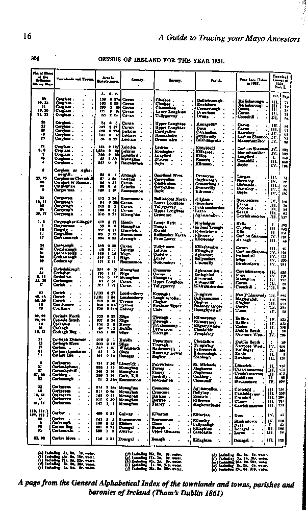
1851. Townland Index of Ireland:
This provides a full alphabetic listing of all of the Townlands, Towns, Civil Parishes and Baronies of Ireland giving their relative location, area and map reference. For each townland the relevant County, Barony, Civil Parish and Poor Law Union is provided.This listing was derived from the areas used by officials in collecting the 1851 Census. It was originally published by Thorn's as 'An Index to the Townlands and Towns, Parishes and Baronies of Ireland '. It has been republished by the Genealogical Publishing Co., i Baltimore, US and is widely available in libraries.
Similar volumes were compiled for the Censuses of 1841, 1861,1871 etc. and may be found in many libraries. The spelling and occurrence of some townlands varied between f censuses and it may occasionally be useful to consult some of these.
, Those conducting research on 17th century records may also be interested in the '1655- 59 Index of Parishes & Townlands of Ireland'. This was compiled and edited by Yann Goblet, based on areas mentioned in Sir William Petty's Mss Barony Maps, and published by the Irish Manuscripts Commission (Dublin 1932) NLI Ir. 9141 gb.
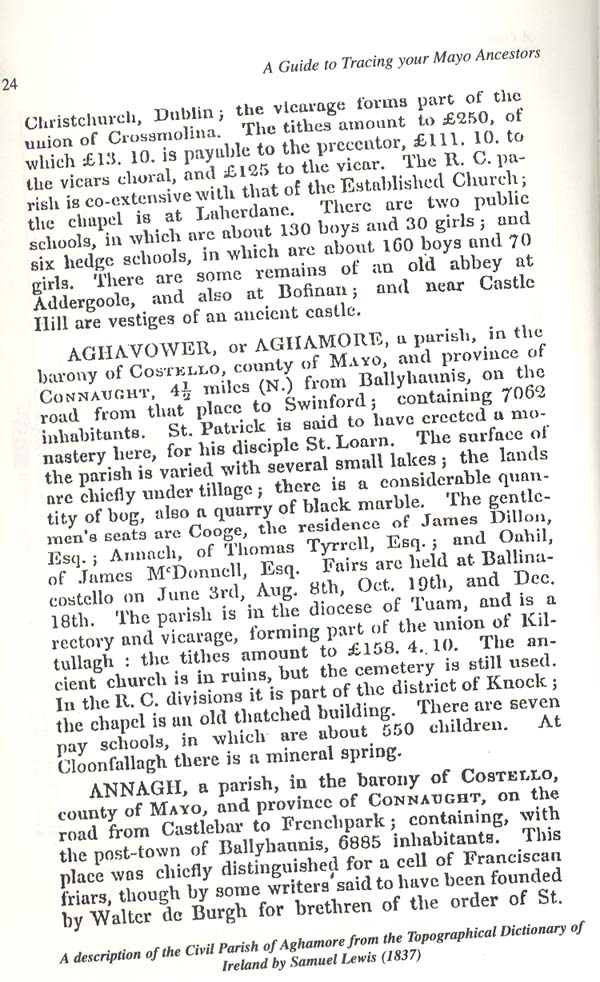
Lewis's Topographical Dictionary of Ireland (1837)
This 3-volume set contains an alphabetically arranged account of all civil parishes, major market towns, seaports and many villages. For each it provides a brief account of local history, social and economic conditions and major landowners (see Fig X). Both Catholic and non-Catholic divisions and churches are also described. A set of 32 county maps accompany this publication. The set has been republished by Kenny's of Galway, and also by Genealogical Publishing Co., Baltimore, US and is widely available in libraries. The maps are also republished in Donal F. Begley's, 'Handbook on Irish Genealogy' (Heraldic Artists, Dublin, 1984).
Parliamentary Gazetteer of Ireland (1844/5)
This is similar to Lewis's Topographical Dictionary in content and arrangement. Published in three volumes-Vol. I A-C (1845); Vol. n (D-M) (1845); Vol. ill (N-Z) + index (1846). NLI Ir. 9141 p30
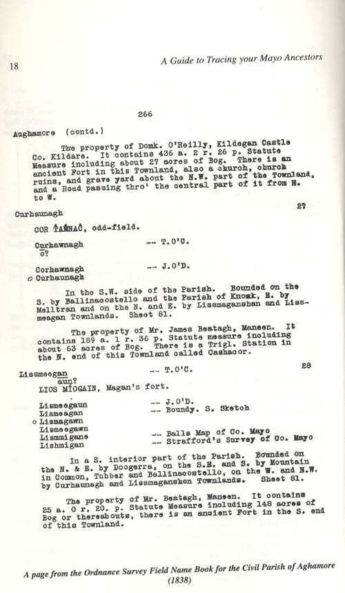
Ordnance Survey Field Name Books
The Ordnance Survey (OS) is Ireland's official State map-maker. The Field Name Books are the notebooks used by the surveyors compiling the fust OS maps of Mayo in 1838. They are arranged by civil parish, and list each townland alphabetically. Although varying slightly between areas, the following details are usually included:
Townland name in Irish & English; Derivation of the name; Location within the parish; Proprietor's name; and other comments (See Fig X).
The original transcripts are on microfilm in the NLI, where the typescripts in hard copy are also held. The reference numbers are as follows:
Transcripts (microfilm) Pos. 4121-3
Typescripts (hard copy) Ir. 92942 03
Book no 97 -Achill-Ballintober
Book no 98 -Ballyhean-Crossboyne
Book no 99 -Crossmolina-Kilcolman
Book no 100 -Kilcommon-Kilgeever
Book no 101 -Killala-Lackan
Book no 102 -Manulla-Thrlough
MAP No. |
CIVIL PARISH |
Alternative Name or spelling |
YEAR(S) OF TITHE APP. |
19 |
ACHILL |
||
16 |
ADDERGOOLE |
1815, 1833 |
|
48 |
AGHAMORE |
Aghavower |
1833 |
70 |
AGHAGOWER |
Aughagower |
1831 |
24 |
AGLISH |
Aka. Castlebar |
1824 |
73 |
ANNAGH |
1833 |
|
14 |
ARDAGH |
1825 |
|
36 |
ATTYMASS |
1834 |
|
59 |
BALLA |
Ballagh, Bal, |
1835 |
52 |
BALLINCHALLA |
Ballincholla |
1835 |
50 |
BALLINROBE |
1827 |
|
30 |
BALLINTOBER |
1833 |
|
27 |
BALLYHEAN |
Ballyhane |
1830 |
18 |
BALLYNAHAGUSH |
1824* |
|
34 |
BALLYOVEY |
1830 |
|
12 |
BALLYSAKEERY |
1829 |
|
72 |
BEKAN |
Becan |
|
43 |
BOHOLA |
Bucholla |
1833 |
26 |
BREAGHWY |
Breaffy, Breaghwee |
|
31 |
BURRISCARRA |
1833 |
|
20 |
BURRISHOOLE |
1832 |
|
69 |
CASTLEMORE |
1826 |
|
55 |
CONG |
||
63 |
CROSSBOYNE |
1842 |
|
13 |
CROSS MOLINA |
1833 |
|
3 |
DOONFEENY |
Dunfeeny |
1834 |
29 |
DRUM |
Drummonahan |
1834 |
46 |
INNISHBOFFIN |
Ennisboffin |
1830 |
23 |
ISLANDEADY |
Islandine, Islandedin |
1833 |
66 |
KILBEAGH |
1825 |
|
17 |
KILBELFAD |
1834 |
|
I4 |
KILBRIDE |
Kilbreedy |
1833 |
61 |
KILCOLMAN |
1824 |
|
67 |
KILCOLMAN |
1832 |
|
2 |
KlLCOMMON |
1834 |
|
51 |
KILCOMMON |
1833 |
|
41 |
KlLCONDUFF |
1833 |
|
5 |
KILCUMMIN |
Kilcommin |
1833 |
42 |
KlLDACAMMOGE |
Kildecamogue |
- |
7 |
KlLFIAN |
Kilfyan |
1815,1833 |
35 |
KlLGARVAN |
Kilgarvey |
1834 |
47 |
KlLGEEVER |
Gilgavower |
1830* |
10 |
KlLLALA |
1833 |
|
38 |
KlLLASSER |
1834 |
|
44 |
KlLLEDAN |
Killedin |
1834 |
22 |
KlLMACLASSER |
1831 |
|
56 |
KlLMAINEBEG |
1836 |
|
54 |
KILMAlNEMORE |
1836 |
|
21 |
KILMEENA |
Kilmina |
1827* |
53 |
KILMOLARA |
1834 |
|
1 |
KILMORE |
1834 |
|
15 |
KILMOREMOY |
1834 |
|
68 |
KILMOVEE |
1827 |
|
65 |
KILTURRA |
Kiltora,Kilturragh |
1834 |
64 |
KILVINE |
- |
|
71 |
KNOCK |
Knockdrumcalry |
1833 |
6 |
LACKAN |
1833 |
|
28 |
MANULLA |
Minola |
1830,1837 |
60 |
MAYO |
||
40 |
MEELICK |
1833 |
|
57 |
MOORGAGAGH |
Moorgaga |
1836 |
11 |
MOYGOWNAGH |
Magaunagh |
1815,1834 |
45 |
OUGHAVAL |
Aughaval |
- |
8 |
RATHREAGH |
Rathrea |
1829,1834 |
49 |
ROBEEN |
- |
|
32 |
ROSSLEE |
1833 |
|
58 |
SHRULE |
Shruel |
1825 |
62 |
TAGHEEN |
Taugheen, Taghkeen |
1827* |
39 |
TEMPLEMORE |
Sraide,Strade |
1833 |
9 |
TEMPLEMURRY |
1834 |
|
37 |
TOOMORE |
Towmore, Tuymore |
1833 |
33 |
TOUAGHTY |
Towaghty |
1834 |
25 |
TURLOUGH |
1825 |
*Only main landholders listed
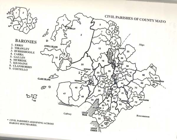
Civil parishes as numbered on map.
1. Kilmore |
20. Burrishoole |
39. Templemore |
58. Shrule |
2. Kilcommon (Erris) |
21. KiImeena |
40. Meelick |
59. Balla |
3. Doonfeeny |
22. KiImaclasser |
41. Kilconduff |
60. Mayo |
4. Kilbride |
23. Islandeady (2 pts.) |
42. Kildacommoge (3 pts.) |
61. KilcoIman |
5. Kilcummin |
24. Aglish |
43. Bohola |
62. Tagheen |
6. Lackan |
25. Turlough |
44. Killedan |
63. Crossboyne |
7. Kilfian |
26. Breaghwy |
45. Oughaval |
64. Kilvine |
8. Rathreagh |
27. Ballyhean |
46. Inishboffin |
65. Kilturra |
9. Templemurry |
28. Manualla |
47. Kilgeever |
66. Kilbeagh |
10. Killala |
29. Drum |
48. Aghagower |
67. Kilcolman |
11. Moygawnagh |
30. Ballintober (2 pts.) |
49.Robeen |
68. Kilmovee |
12. Ballysakeery |
31. Burriscarra |
50. Ballinrobe |
69. Castlemore |
13. Crossmolina |
32. Rosslee |
51. Kilcommon (KiImaine) |
70. Aghamore |
14. Ardagh |
33. Touaghty |
52. Ballinchalla |
71. Knock |
15. Kilmoremoy |
34. Ballyovey |
53. Kilmolara |
72. Bekan |
16. Addergoole |
35. Kilgarvan |
54. Kilmainemore (2 pts.) |
73. Annagh |
17. Kilbelfad |
36. Attymass |
55. Cong |
|
18. Ballynahaglish |
37. Toomore |
56. Kilmainebeg (2 pts.) |
|
19. Achill |
38. Killasser |
57. Moorgagagh |